Wednesday, December 9, 2020

Ways to Get Involved

My hope is that from reading the success that Polk County Conservation has experienced inspires others to get involved and make a change. As a Wildlife Biologist, it inspires me to see change actually happening via staff who have a passion for their job as well as adequate funding resources. In my current position, funding is often limited and purchase methods seem to be more cost prohibitive than productive. I understand some of this is going through the 'red tape', but I also look forward to advancing my career in the future to areas that have adequate funding.

As such, I wanted to provide resources for people who wanted to get involved with Polk County Conservation.

Volunteering


Polk County Conservation (PCC) has all sorts of opportunities for people to get involved. Prior to doing so, you must fill out a volunteer application. They also ask that everyone reads, signs, and adheres to the volunteer Code of Conduct. This is important to ensure that certain standards are met to allow all involved to have a positive, safe, and learning-conducive time. 

PCC publishes what appears to be a quarterly Volunteer Calendar, describing opportunities you have to get involved so you can plan well ahead of time. Two of the things on their current calendar - invasive species removal and seed harvest are components of ecological restoration that I have become passionate about. I am working extensively to remove invasive species at my current place of work as well as implement a grassland restoration project to restore some of Virginia's native prairies back to their former glory. These are two programs with Polk County I would definitely encourage anyone who is interested to get involved with. Many, MANY hands are needed for both of these assignments, your efforts will always be needed. 

PCC also has public volunteers days (2x/month) where the public can come out and make a difference on one of the other projects PCC has going on. These projects range from trash pick up to trail maintenance, waterway cleanup and more! They also offer Private conservation events - I'm curious myself on what this entails!

Adopt a Park - PCC has several parks available that volunteers can 'adopt', conducting work day events throughout the year as needed. Bird boxes, clean-up events, trail maintenance and other beautification projects are among the list of many things you can get involved with. For more info, see their Adopt-a-park Flyer!

There are plenty of volunteer opportunities with PCC to do nearly any conservation related project you can think of. They even seem to be open to creative projects as well, so feel free to suggest your own. It seems as though they have tons of work, so don't be discouraged if your idea isn't utilized just yet. As conservation professionals, they too have goals they would like to meet annually related to their personal and professional goals.

They also have an 'Events' component with their program. These seem to be more geared towards fun, outdoors events rather than projects. While projects have their place, sometimes we just need to connect with the outdoors and just be. They have several hiking events, with one that looks enticing just because of it's name and photo associated with it: Hike and Hot Cococa. For more information on Events, please go to their Events page. Events due require registration prior to attending. Likely this is due for planning purposes. Planning ahead of time will allow an adequate staff to volunteer ratio, allow staff to provide proper equipment for everyone, and to also ensure that too many people don't sign up for one task. While that seems slightly silly, there are many areas of need and spreading the wealth of volunteers is extremely beneficial to conservation professionals. 

For those looking for less 'hands on' physical labor type volunteer opportunities, Jester Park is the place for you! There is a need for all sorts of volunteers, one is not greater than the other. Jester Park has volunteer opportunities to help greet visitors, provide information similar to that above with events and programs going on, and directing people to trails. For more information about Jester Park volunteer opportunities, please click here.

If you have questions/concerns/comments with any of the volunteer opportunities, the best contact would be to e-mail ConservationVolunteers@polkcountyiowa.gov. They will be able to respond to whatever inquiries you may bring.

I hope this provides anyone interested with resources to get them started on volunteering with Polk County Conservation. They are doing great things in the area and I hope to be a part of the volunteering someday myself!  

Saturday, December 5, 2020

Creating a a mobile app

For this assignment, I was tasked with learning how to build a mobile app via MIT's App Inventor Interface. We weren't necessarily tasked with create an app that was directly related to our watershed (as that would require extensive involvement into a pseudo-programming atmosphere), but we were to experiment with a few app tutorials and try a basic app.

As an avid fan of mini golf, I chose to do the mini golf application tutorial (initially the ball bounce tutorial). The video was very short, and gave the basic information, but I decided to go a little deeper into the more in depth tutorial on the mini golf app to see what that entailed.

A quick disclaimer: I had lots of difficult setting up the emulator (required if you don't have an android phone that can download MITs aiStarter). It seemed it didn't worked right at the beginning, but restarting my computer seemed to help.

The programming interface was relatively intuitive. I took a basic programming course in high school and thoroughly enjoyed it. For whatever reason, that's as far as I took it, and never continued with programming. As a professional, I use microsoft excel and formulas within excel quite extensively. I also recently took a Microsoft Access course for database management but I don't think I will be learning to program access in any amount of depth - it is very involved, people spend years learning access. I've also started to learn R for data management, but that may be another that I don't get too involved in. I like R for it's ability to replicate manipulation of data. For example, if I needed to perform an annual accounting document from a license sales file, with proper R code, I can spit out a report with the relevant data I need from a larger dataset with just a click of a button, rather than recoding it every time in excel.

Back to the MIT App Inventor

So I was able to replicate the minigolf game through the first 3 steps (it's basically just following along a PDF guide). I mostly had success, with some minor errors that I couldn't figure out. Below is the game with the mobile emulator (right) and the programming on the left.


I thought the programming side of things was relatively easy to replicate, however more time would be needed (maybe a semester long course, or lots of spare time) in order to be able to successfully create my own app from scratch. It does seem intuitive, but that's also because I was just replicating their example. I think to learn this well, one would need to do each of their examples to their full extent, as I'd imagine they cover each of the "Components" throughout those tutorials. 

Occasionally, the PC emulator wouldn't incorporate the changes I made on the programming side, so I would have to just shut it and reconnect via the website and it worked fine.

Thinking about the simplicity of this app but the amount of 'programming' required - mainly just lines of nested code - I'd imagine it would be extremely time consuming to make an app that had multiple purposes.

Tuesday, December 1, 2020

Wetland Mitigation Banking

Wetland Mitigation Banking

First, a little background:

In 1948, the Federal Water Pollution Control Act was established, paving way for the establishment of the Clean Water Act (CWA) in 1972 by the Environmental Protection Agency (EPA). Essentially, the CWA sets regulations for water quality by regulating pollution discharges into waterways such as sewage and fertilizers, wetland take, and clean water standards. As it relates to wetland mitigation (and subsequently mitigation banking), the CWA has a provision - Section 404 - that establishes regulations for the discharge of dredge material to fill wetlands that would otherwise be unavoidable, this includes any sort of damage/alteration of the quality of the wetland as well. Evidence has to be provided by the organization requesting the 404 permit showing that 1) steps have been taken to avoid impacts to wetlands/waterways, 2) potential impacts have been minimized, and 3) all unavoidable impacts will be compensated. These applications are reviewed by the United States Army Corps of Engineers (USACE). General permits exist - those resulting in smaller impacts (minor road maintenance, utility rights of way) some of which can be used through statewide programs. More information on these specific matters can be obtained on the USACE website.

Wetland Mitigation is the compensation for the destruction of wetlands (as permitted by the CWA as discussed above). This facilitates an 'offset' of the loss of wetlands by restoring, creating, or enhancing wetlands, resulting in a 'no net loss' of wetlands. While that sounds all well and good, at times, this is fatal for certain species, especially those that breed in ephemeral wetlands. I'm unsure of the exact requirements, but I from conversations I have had, I do not believe that these wetlands are required to be 'mitigated' within the same general area.

With wetland mitigation banking, credits can be purchased to offset adverse wetland impacts from an organization. Often, sponsors design, create, establish and maintain wetland mitigation banks, then sell these 'credits' to organizations looking to offset wetland destruction (take). There are a finite number of credits per 'bank'; once these credits have all been purchased, this bank can no longer be used to offset wetland take. This can be extremely advantageous in that in an area such as Fourmile Creek (see video below), sponsors and conservation groups can work together to establish wetland mitigation banks for their own purposes: in this case, restoring the Fourmile Creek Watershed by creating wetlands along the creek, which then help reduce the adverse impact flooding events have. In this situation, Polk County Conservation and JEO are working together to restore stream flows to their native directions (oxbow restoration) and restore native vegetation to the area. While I don't have experience these types of projects, this does seem like an excellent way to handle wetland restoration in that it allows managers to determine what the need is and establish effective plans proactively rather than retroactively. I'm unsure of the timeline companies have to mitigate wetlands in the event banks don't exist. Mitigation facilitates this, possibly making timelines more rapid, but also providing an immediate solution for the needs of conservation groups.

JEO Consulting Group, an engineering firm conducted a stream assessment for the Fourmile Creek Watershed, also creating a simulation video of what a portion of the stream would look like with wetland mitigation banking.


For more information on wetland mitigation banking, see NRCS: Mitigation Banking.

Additionally, NRCS has created a story map that explains more on Wetland Mitigation Banking.


Sources:

EPA Clean Water Act Summary: https://www.epa.gov/laws-regulations/summary-clean-water-act
EPA Clean Water Act, Section 404: https://www.epa.gov/cwa-404/permit-program-under-cwa-section-404#:~:text=Section%20404%20of%20the%20Clean%20Water%20Act%20(CWA)%20establishes%20a,the%20United%20States%2C%20including%20wetlands.&text=Proposed%20activities%20are%20regulated%20through,required%20for%20potentially%20significant%20impacts.

USDA NRCS Wetland Mitigation Press Release: https://www.nrcs.usda.gov/wps/portal/nrcs/ia/newsroom/releases/NRCSEPRD1330430/

USDA NRCS Conservation Compliance and Wetland Mitigation Banking
https://www.nrcs.usda.gov/wps/portal/nrcs/detail/national/programs/farmbill/?cid=NRCSEPRD362686

United States Army Corps of Engineers:
https://www.mvr.usace.army.mil/Portals/48/docs/regulatory/mitigation/Iowa%20Mitigation%20Banking%20Guidance%20Package_reduced.pdf

US EPA - Wetlands
https://www.epa.gov/wetlands/wetlands-restoration-definitions-and-distinctions

Wednesday, November 11, 2020

What are Alluvial Soils and why are they Important?

Alluvial Soils

Alluvial soils are soils transported and deposited during flood events. As such, volume and frequency of deposition varies per event, often resulting in 'stratification' of soils, or distinct layers, visible when looking at a 'soil profile' - or horizontal cross section of soil layers, distinguishable by color differences among the different layers. As time passes, various weather events - the drying out of soils by the sun/wind, freezing and thawing cycles, breaks down larger soil particles, creating opportunities for future flooding events to deposit various nutrients from broken down larger soils further downstream. Alluvial soils in floodplains are nutrient rich soils, resulting in fertile areas highly suitable for crop growth. Often in developed lands, soil deposition occurs at a faster rate and can do more harm than good when this soil deposition is a result of massive amounts of erosion or transports high nutrient loads from agricultural lands (fertilizers and nitrogen) further downstream.

Within the Fourmile Creek Watershed, two main soil regions exist: Loamy Wisconsin Glacial Till and Loess Ridges and Sideslopes. The images below are from USDA NRCS document discussing the various soil profiles in Iowa. The top two images describe the main two soil regions within the Fourmile Creek Watershed.


(Figure 1: Description of Soil Regions)


(Figure 2: Map of Iowa Soil Regions)

Alluvial Soils within Fourmile Creek

Iowa DNR has established an online mapping program to determine if alluvial soils and/or alluvial aquifers exist within an area. They have a very specific reason for making this information available online: Proper Animal Feeding Operation (AFO) Siting Atlas. Iowa State Law prevents livestock and poultry producers wishing to construct or modify an existing feeding confinement area, open feedlots, or a manure storage structure within a 100-year flood plain. (a 100 year flood plain simply means that each year, there is a 1% chance - 1/100 of a flood event occurring within an area; as such a 500 year flood plain means there is a 0.2 % chance of a flood event occurring with an area). The law is intended to prevent contamination of a water source. 

I used their Siting Atlas to clip manually clip my own areas of interest - the Fourmile Creek Watershed (Figure 3). As depicted, land within/adjacent to the stream all contains land within alluvial aquifers/alluvial soils. Additionally, Iowa DNR provides siting information with information including distance to major river, distance to surface water, percent slope, and well distance (Figure 5). In order to obtain this information, you have to select an individual point on the map - this is where the useful ness for agricultural operations comes in. They are able to use this Siting Atlas to find a specific point on their land to preliminarily determine if the lands lie within the alluvial soils area. Figure 4 shows a zoomed in version of a subsection of the Fourmile Creek Watershed, highlighting to areas delineated as having alluvial soils and alluvial aquifer. I chose a section near agricultural lands given the intended utility of this Siting Atlas. 

(Figure 3: Map of alluvial aquifers and soils within the Fourmile Creek Watershed)

(Figure 4: Zoomed-in map of a subsection of the Fourmile Creek Watershed)

 
(Figure 5: Point-specific siting information)

Sources:

Iowa DNR: https://www.iowadnr.gov/Environmental-Protection/Land-Quality/Animal-Feeding-Operations/Mapping/Proper-AFO-Siting

Iowa DNR AFO Siting Atlas: https://programs.iowadnr.gov/maps//afo/

Iowa Soil Associations: https://www.nrcs.usda.gov/Internet/FSE_DOCUMENTS/nrcs142p2_006362.pdf

USDA NRCS: https://www.nrcs.usda.gov/Internet/FSE_DOCUMENTS/nrcs142p2_006038.pdf

https://soilsmatter.wordpress.com/2020/02/15/what-are-alluvial-soils/

https://www.sciencedirect.com/topics/agricultural-and-biological-sciences/alluvial-soils


Flood Plain Mapping

Flood Plain maps:

Flood Plain mapping is important for various reasons. For agriculture, it's important to know what areas may inundate from time to time, possibly reducing crop yield. For home owners, it's important to know not only what your risks are, but some localities require you to have flood insurance as a result, and the premiums for this can be high. It is important for understanding water flow, especially when it comes to nutrient loads, sewage runoff - mostly older systems - and other sources of pollution into waterways. Des Moines established a flood-program buyout plan back in 2018 following a major flood event to purchase land back from homeowners at 110% of the assessed property value. There are also projects in place to both reduce the amount of nutrient run-off into the watershed. 

The city of Ankeny, one of the areas in which the Fourmile Creek flows, established the "Ankeny Plan 2040" in 2018, highlighting a plan for various aspects of the growth of the town including topics such as the Environment, Population & Growth, Transportation, and Infrastructure, among 10 other chapters regarding the future of the city. Chapter 4: Environment covers extensively future plans for essentially all things watershed, including vegetation management (buffers, native species, riparian zones), and storm water management, providing an excellent summary of watershed management in Ankeny.

For an even MORE in depth study of Fourmile Creek, Snyder & Associates, Inc. conducted a Fourmile Creek Watershed Study in 2013, assessing numerous aspects of the stream, stormwater management properties, and land management.

Below, I have utilized Iowa's Flood Hazard Maps on their website - 'Iowa Flood Information System' to take screenshots of the flood plain. For more information on the system, see an earlier blog post I wrote on the topic


(Image Sources: Screen shots taken from Iowa Flood Center Mapping Online via https://ifis.iowafloodcenter.org/ifis/newmaps/hazard/)

I zoomed in specifically on a section in the northern part of the watershed with housing nearby highlighting the use of flood plain mapping in development. I've also enlarged the Legend to highlight the various delineations. The top image is a portion along Fourmile Creek surrounded by residential neighborhoods. The bottom image shows flood plain delineations. 


Sources:

2018. Des Moines Register. Polk County board votes to contribute up to $1 million for flood buyouts. Available from https://www.desmoinesregister.com/story/news/2018/08/07/des-moines-flood-buyout-program-1-million-polk-county/925003002/

Iowa Flood Center. Available from https://ifis.iowafloodcenter.org/ifis/maps/hazard/.

2018. Ankeny Plan 2040, Chapter 4: Environment. Available from https://www.ankenyiowa.gov/home/showdocument?id=5724.

Sunday, November 1, 2020

Invasive Species

Invasive Plant Species in the Area

I have created a slideshow with an overview of some common invasive plant species in Iowa. I've included the ones that are commonly treated by Polk County Conservation for eradication n the Fourmile Creek Watershed area.

Prior to the slideshow, I wanted to share a video of Blank Park Zoo, located in southern Des Moines, not too far outside of Fourmile Creek Watershed. They've taken a very unique and interesting approach on tackling invasives.  They dual purpose invasive plants by removing them and using them as browse and/or enrichment.

Source:http://www.iowapbs.org/iowalandandsky/story/35326/invasive-species-removal-benefits-park-and-zoo-animals

This is an excellent idea! In this case, professionals who know what they are doing are removing appropriate tree species and being careful not to spread seed of any non-native plant. This is an extremely important note to make, as taking care not to unintentionally spread seed is of utmost importance.

Here is the slideshow of invasive species that I have put together. Below the slideshow are a few more recommendations for best management practices as well as additional resources on other invasive species throughout the state of Iowa. 


Iowa Environmental Focus suggests these steps (these are great practices anywhere)

Do not buy/sell firewood outside of your county. Emerald Ash Borer can spread this way.

Remove seeds from shoes/clothes after being outdoors as this can be an unknowing way of spreading invasives.

Remove invasive plants where you recognize them. Iowa Environmental Focus suggests getting involved with parks/groups who focus on invasive species removal. I would highly caution removing invasive species yourself  unless you are 100% of of species idea as some invasive plant species look very similar to others. Twice within the last year I have had to be careful with what I was removing to be sure I wasn't removing native plant species. I've been doing a fair bit to remove tree of heaven seedlings from an area where I currently work in Virginia and caught myself (after I pulled it unfortunately) removing a Shining Sumac (Rhus copallinum). I was more careful with every subsequent removal. The second time I was making strides to remove Persian Silk Tree (Albizia julibrissin) from an area and found many seedlings. I also noticed to that Partridge Pea (Chamaecrista fasiculata) was present in the area, discernable in my case by the tiny plants flowering and some having seed pods. I took care not to remove these as they are beneificial native species. As legumes, they share similar leaf characteristics as the invasive Silk Tree.

Source: https://iowaenvironmentalfocus.org/tag/invasive-species/

Boating - ensure that when you trailer your boat from a day out, you remove invasives from the boat trailer. Duckweed (Lemna sp.) commonly spreads this way as well as hydrilla (Hydrilla verticillata).

Iowa Invasive Plants: https://www.iowadnr.gov/conservation/forestry/forest-health/invasive-plants

Iowa Invasive Aquatics: https://www.iowadnr.gov/Fishing/About-Fishing-in-Iowa/Fighting-Invasive-Species

Invasive Inverts: https://www.iowadnr.gov/Fishing/About-Fishing-in-Iowa/Fighting-Invasive-Species/Aquatic-Invasive-Invertebrates

Invasive Fish: https://www.iowadnr.gov/Fishing/About-Fishing-in-Iowa/Fighting-Invasive-Species/Invasive-Fish

Invasive species good general background info: https://naturalresources.extension.iastate.edu/invasives

Saturday, October 24, 2020

Rapid Watershed Assessment and RASCAL

The Natural Resources Conservation Service (NRCS) in Iowa has been working towards all watersheds in Iowa having watershed assessments performed via the Rapid Watershed Assessment (RWA) method. The goal is to efficiently and effectively assess each of Iowa's watersheds to then put the results in the hands of those making decision (i.e. local managers/governments). As such, I will be discussing the tools used for the RWA assessment. Within each assessment, the following topics are generally addressed: Land use/cover, physical resources, water quality report, soil, stream, precipitation data, census/social data, resource concerns, progress/status of conservation by land use and estimated future projects and associated costs.

The image below depicts those watersheds that are either in progress, outlined in red or completed, outlined in black.

(Image source: USDA NRCS Iowa; https://www.nrcs.usda.gov/wps/portal/nrcs/ia/technical/dma/rwa/)

Based on this image, the south fork of the Des Moines River Watershed has not been evaluated to date.

What is interesting about the current progress on the RWAs according to the NRCS website, is that the first one was published in October of 2007 and the latest one was published in October 2012. They did mentioned on the website that this was a five year project, so I'm curious if they used all of their funding on the watersheds already surveyed.

**Update** - I connected with an Iowa USDA NRCS representative about the RWA. The intent was never for NRCS to cover all of the watersheds in Iowa, but to empower and enable other groups to be able to put together high quality reports to express the needs for watershed projects.

As there already is a plan in place, I am choosing to move forward with exploring various aspects and tools to accomplish the goals to complete Polk County's projects.

RASCAL

Along the Fourmile Creek Watershed, a stream assessment tool - RASCAL - Rapid Assessment of Stream Conditions Along Length - is being utilized to assess watershed conditions. RASCAL uses various in-stream and adjacent-to stream attributes to give watershed managers priority areas for allocating often limited funds to areas of highest conservation need. In-stream metrics include substrate type, pool frequency, bank height/stability/vegetation characteristics, and water clarity. Adjacent-to-stream metrics include numerous riparian zone characteristics - width/cover/vegetation height and composition, canopy cover, adjacent land use, pollution sources.

I spoke with a Polk County Conservation staff member who described some of the measurements taken on a recent training on stream assessment using RASCAL.

She indicated that they recorded data that allowed them to take a longitudinal profile. Some of the measurements taken aren't necessarily for conservation staff per se, as much as they are for engineers whose job is to develop mitigation plans for certain stream segments. They took water level data along the center of the stream and was as cross section measurements of the water level. When entered into appropriate software, this develops a 3-D model of the stream, allowing planners to tailor mitigation strategies for areas that for example may be prone to higher erosion. They would take these measurements anytime they transitioned from a riffle to a pool, or viceversa, but also when there was any apparent clear elevation change. Those are important aspects of assessment when developing a longitudinal profile. She noted that during drought years, stream surveys may be harder to conduct because 'bankfull height' sometimes may be hard to determine due to lack of a high water line or vegetation growth. On a normal precipitation year, you may have periods without rain, but the vegetation line won't have reestablished. When I visited Polk County Iowa in September, I noticed a similar occurrence in Saylorville Lake. She indicated that they also take 'pebble counts' within a riffle that helps determine stream flow in that area, sediment deposition behavior, and looking at how far erosion may take sediments based on sediment origin.

Within the Fourmile Creek Watershed, using RASCAL has enabled staff to delineate the entire stream as far as erosion status is concerned, also enabling them to predict areas of future concern.

(Image Source: http://www.iowasrf.com/media/cms/SRFwatershed1015_8D42352185B5A.pdf)


Monday, October 12, 2020

Historic and Current Agricultural Practices

Brief Historical Context

Most of Iowa's prairies are a result of glaciation estimated at 12,000 years ago. This resulted in a fairly large portion of Iowa being inundated by standing water. This led to a high water table and rivers accustomed to having a wide-berth flood plain. In fact, approximately 6 million acres of agricultural cropland in Iowa where excess water can limit agricultural and therefore economic productivity (Hofstrand, 2010). While the result of this was rich fertile soil, high water was not conducive for agricultural cropland, at least not successful cropland anyway. Counties throughout the state began to develop methods of draining and diverting the water to access the rich soils; in comes tiling.

Tiling


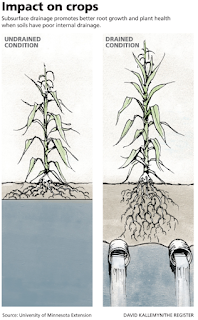
Historical agricultural practices known as 'tiling' have resulted in often channelized water diversion systems beneath crop fields reducing the amount of standing water in the water table. The two images below show examples of how tiling affects the water table.


For farmers, pooled surface water and elevated (natural) high water levels within the water table decrease crop success and yield. Tiling enabled them to effectively lower the water table, reducing the amount of water in the soil, allowing them to take advantage of the fertile soils. Tiling, however, also increases the rate in which nitrates are filtered from livestock lands and fertilizers and flow into larger creeks, eventually ending up in the Gulf of Mexico. In the video below, you will hear that one of the watersheds in Iowa (Raccoon River) has possible the highest nitrate content in North America solely due to tiling practices.

While tiling may not be ideal from a conservationist's perspective as it relates to natural water flow, storm water mitigation strategies and assessing flood risk, agricultural crop yields are an important part of our country's economy and well as individual livelihood. It is of utmost importance to work together to find long-term strategies to essentially retrofit existing tiles underneath agricultural lands as well as provide opportunities for farmers to implement tiling in a water-conscious and environmentally friendly way. On a personal note, I've found within the last year or so as a professional that there are times where you may just want to say, "this isn't the way to do this, you must stop" or "We're not going to do as you want, because it's not beneficial to the natural world". This approach is far from what we need as we can just look to the status of our nation as we continue to have more polarized views. I have found that working together to come up with a solution palatable to both sides (when possible) often yields better results/relationships.

Where do we go from here?

In the PBS video below - Comparison of Two Watersheds - Chris Jones, a Water Quality Research Engineer with the University of Iowa, discusses issues with nitrate and phosphorous levels in the Raccoon River Watershed in Iowa. State and federal funding are in the works to mitigate nitrate levels within the watershed. 


The Iowa Nutrient Reduction Strategy was developed in 2012 in response to the Mississippi River/Gulf of Mexico Watershed Nutrient Task Force (est. 1997) attempting to reduce nutrient loads in the Gulf of Mexico. In their 2008 Action Plan, they requested each of the 12 states along the Mississippi to develop a nutrient reduction strategy. The Iowa Department of Agriculture and Land Stewardship, Iowa State University and the Iowa Department of Natural Resources worked together to develop this strategy. In November of 2012, the first Iowa Nutrient Reduction Strategy was drafted and has had four revisions since (2013, 2014, 2016, 2017). The goal of the INRS is to reduce the combined nutrient load of Nitrogen and Phosphorous by 45% annually. For more information on nutrient pollution in the Mississippi River Watershed, review this excellent overview online describing the adverse affects the Gulf has faced due to high nutrient level input from the watershed.

In summary, here are the preliminary results:


The 2006-2010 benchmark load serves as a baseline for just before when the Iowa NRS was established.

As I mentioned earlier, farmers do work together with extension agents to develop best management practices on their lands in efforts to reduce nutrient offloads from their tiled lands. . The Natural Resources Conservation Service (NRCS) has resources available online addressing nutrient loads, financial assistance, and conservation planning, among others. Under the Nutrient Management page, several options are listed as ways to reduce nitrogen outputs in waterways including reducing fertilizer/pesticide use, using cover crops/no-till methods to reduce erosion (thereby runoff), or implementing Drainage Water Management (DWM) systems. Retrofitting existing tiled lands can be done through DWMs, allowing tiling practice to continue, but reducing the overall output of nitrogen into watersheds. In some cases as reported by NC State University, drainage systems can even increase crop yields by installing DWMs. They conducted a 20-year study yielding a 10.4% increase in corn yield as well as positive yields in soybean fields as well.

I've found two examples of farmers working to reduce their farm's impact on watersheds:

In this article, a farmer in Northern Ankeny has implemented two of the nutrient reduction practices - installing a bioreactor and creating saturated buffers. The bioreactor uses a large container full of wood chips that acts as a filtration system. Water from the tiling system flows through it and microbes on the wood chips utilize the nitrogen from the incoming water, filtering the pollutant out. The saturated buffers divert the water from the tiling system into another tiling system that runs parallel to a vegetated buffer, allowing for smaller amounts of the filtered water to percolate out of the parallel system. The remaining nitrogen is up taken by the vegetation, removing it before it can reach the watershed.


    Installation of a bioreactor. Image Source: Polk SWCD.


    Installation of a bioreactor. Image Source: Polk SWCD.


Another family in Northern Polk County also recently implemented a tiling system and a bioreactor on their farmland. For years they have been participating in nutrient mitigation strategies by installing buffer strips along water ways, have taken measures to reduce erosions and have installed grass waterways.

There are many programs in place to help offset the overall cost of implementing these structures on the landscape. In fact, USDA just granted $1 milllion to Iowa for assistance with another program - wetland mitigation banking - that is often unaffordable for agricultural producers.

NRCS has provided a brief PDF document summarizing all of the above. This is a great PR tool to hand out to folks who are unsure of what exactly does Drainage Water Management mean, and how does it affect the producer overall. As stated on their website, reducing the input of materials into the system to begin with (fertilizers/pesticides) is the start, but realistically, moving to the next stage in the system will better reduce the amount of nutrients input into the system and is also a more attainable goal for farmers, while still maximizing their agricultural yield, and in some cases even increasing it.


Sources for this post: 

Hofstrand, D. 2010. Understanding the Economics of Tile Drainage. Iowa State University Extension and Outreach. Available from https://www.extension.iastate.edu/agdm/wholefarm/html/c2-90.html

INRC. 2020. Iowa Nutrient Reduction Strategy 2018-19 Annual Progress Report. Available from https://store.extension.iastate.edu/product/15915

Iowa PBS. 2018. Comparison of Two Watersheds. Available from http://www.iowapbs.org/iowalandandsky/story/31804/comparison-two-watersheds 

NRCS. n.d. NRCS Iowa Home Page. Available from https://www.nrcs.usda.gov/wps/portal/nrcs/ia/home/

Sunday, October 4, 2020

Watershed Organization Research

This week, I elected to explore in depth Polk County Conservation. From previous research, I noticed how much they are doing within the central Des Moines area and wanted to highlight the projects they have going on. I have included a slideshow below with my findings.


Sunday, September 27, 2020

Comparative Land Use within the Fourmile Creek Watershed

When considering the watershed as a whole, it is necessary to understand and evaluate the various land uses within to appropriately understand what influences a use may have on the system. Additionally, this will guide us on what metrics we need to obtain to evaluate the watershed and to help us better identify the response to issues pertaining to the watershed. Below I have put together a slideshow that discusses the various land uses with the Fourmile Creek Watershed.

Friday, September 25, 2020

Iowa Flood Information System (IFIS)

 As second part of my previous post on Flood Data for Iowa, I came across the Iowa Flood Information System - IFIS.


This website seems like a one-stop shop for all things weather/flood related for Iowa. It's a more succinct version of what the USGS offers and the user interface seems to be better. You can explore flood inundation maps, flood conditions and forecasts, traffic conditions, a time-adjustable flood risk calculator, rainfall frequencies, weather data, and soil moisture gauges, among a host of other features. They have a downloadable mobile app - download here

It seems like a great mobile app to have if you live/work in Iowa and have concerns about flooding/water levels.

Wednesday, September 23, 2020

Central Iowa flood of 2018

In June of 2018, Central Iowa observed a major flash flood event caused by a storm system that dumped anywhere from 5" to 10" of rain overnight on June 30. The result yielded highly flood creeks, some creeks were destroyed and record water levels were observed in Fourmile and Walnut Creeks (NWS 2018). Flooding caused a water main break, forcing some residents to boil water before using and had residents kayaking through neighborhoods (Des Moines Register 2018a). The boil order was lifted for most residents after locating the break, but some still fell within the order. One duplex townhome actually exploded (Des Moines Register 2018b). No one was harmed in the explosion, but they did narrowly escape.

The same could not be said for 'local legend' Larry Cotlar. Cotlar was an announcer for Drake's basketball team for over 10 years as well as for the Iowa Barnstorms, a professional indoor football team located in Des Moines (We are Iowa 2019).

A twitter feed dedicated to these events can be found here: Des Moines/Ankeny Catastrophic Flash Flooding. Many photos and videos are embedded within that feed.

Below is an aerial video taken 


What has the response been:

After the floods, the follow actions were taken (We are Iowa 2019):

A 1% increase in sales tax was imposed in Polk County. The first 50% was dedicated to property tax relief, and the remaining 50% was dedicated to upgrading infrastructure.

Concrete boxes have been buried beneath the street to help delay storm surges, allowing sewers to catch up with the heavy water flow.

100 homes were identified as being eligible for a flood plain buyout at 110% of their home value. 80 of the 100 homeowners agreed to the buyout.

Here is another video of a neighborhood - St. James Place in Ankeny that borders Fourmile Creek. This youtube channel recorded footage of the creek a week prior to the flooding. 


1. NWS. 2018. June 30, 2018 Central Iowa Major Flash Flood Event. Available from https://www.weather.gov/dmx/20180630_EpicFlashFlood

2. Des Moines Register. 2018a. Ankeny water main break located; most of the city's boil order canceled. Available from https://www.desmoinesregister.com/story/weather/2018/07/01/iowa-flooding-ankeny-under-boil-order-after-major-water-main-break-des-moines-weather-forecast/748927002/

3.Des Moines Register. 2018b. Urbandale couple escapes death in flash flood: 'Next thing I know, we were underwater'. Available from https://www.desmoinesregister.com/story/news/2018/07/01/des-moines-flooding-urbandale-couple-survives-flood-drowning-home-explosion/749441002/

4. We Are Iowa. 2019. Floods of 2018: Lessons Learned. Available from https://www.weareiowa.com/article/news/local/floods-of-2018-lessons-learned/524-504911b7-e5fa-4d4c-a1e8-f681b981778c

Exploring Flood and Drought Data of the Watershed

Using the Advanced Hydrologic Prediction Service from the National Weather Service anyone can look at various information pertaining to a watershed.

The Fourmile Creek Watershed has 7 gauges available to explore (Figure 1)

(All images from https://water.weather.gov/ahps/). 

The symbology of the gauges within the stream indicate:

    6 of the 7 gauges do not have forecasts or probability data available
    5 of the 7 gauges do not have a defined flood category
    1 of the 7 gauges does not have current data available.


Figure 1. Stream gauges within the Fourmile Creek Watershed


Figure 2. Fourmile Creek at Easton Blvd. detailed flood stage information

In Figure 2, a Flood Stage Level of 12.5 feet. Upon double clicking the stream gauge, the image is enlarged and I am given numerous other features to explore. This stream gauge status is updated by past precipitation data as well as forecasted precipitation within 24 hours. I was also able to find more information about multiple flood stage levels (Figure 3).


Figure 3. Scale to Flood categories at Easton Blvd. in the Fourmile Creek Watershed

In 2018, this stream crested at 17.51 feet, the highest on record for this location. There is an option to turn on a FEMA flood layer (Figure 4). When I change the basemap, you can see how the flood plain overlaps with residential neighbhorhoods. Taking this one step further, I looked at the next upstream gauge. While this gauge doesn't have up-to-date forecast data, it's important to note that many agricultural lands are within the floodplain. As such, Polk County Conservation has begun purchasing land from homeowners (both residential and agricultural lands) to restore flood plains and stream channels to their natural channels. One of the main considerations for purchasing lands is to increase storm water management efforts, reducing the effects of erosion and flood waters.

Figure 4. FEMA National Flood Hazard Layer

Figure 5. FEMA National Flood Hazard Layer with Satellite Imagery Basemap

As I stated above, flooding in Fourmile Creek reached an all time high in 2018. During this period, a major flash flood event occurred as a result of thunderstorms stalling out over central Iowa, resulting in 5-10 inches of rain, streams flooding over their banks, and record water levels in both Fourmile Creek and Walnut Creek. A follow-up post will go over this event in depth.

Thursday, September 17, 2020

Dendrology of the Fourmile Creek Watershed

Here, I've created a slideshow of the most common trees within the watershed that I came across while visiting the area in September of 2020. I biked a 15 mile loop from Copper Creek Lake Park along the Chichaqua Valley Trail to Mally's Weh-Weh-Neh-Kee Park. Weh-Weh-Neh-Kee is a Meskwaki people term for 'a good place'. The Meskwaki people inhabited Iowa in the mid-1800s. For more information on this tribe, you can visit their website. Fourmile Creek bordered the Chichaqua Valley Trail for a good portion of the 15 mile ride.


The image on the left is from my starting point (Copper Creek Lake Park, bottom) to Mally's (top). The image on the right shows a zoomed in section of the trail. Here you can see where Fourmile Creek butts right up against the trail.

Anyway, without further ado, here's my presentation:

Wednesday, September 16, 2020

Fourmile Creek Watershed Map

Below is a slideshow with some specs on the Fourmile Creek Watershed. I chose to use Arcmap, as I'm more familiar with that than I am Google My Maps, plus I like to keep my GIS skills sharp as I use the program at work as well. I'm a firm believer (mainly from experience) in: "If you don't use it, you lose it".

I initially used a webpage through Iowa DNR (Iowa Elevation Tools - LiDAR elevation profile) to determine the stream elevation change. With this webpage, I selected two points (Image 1), headwaters and mouth, approximately and came up with an elevation change of 273.3 (Image 1). I then attempted to download a Digital Elevation Model (DEM) raster in Arcmap and couldn't figure out how to accurately assess elevation change. After doing some research, I found a study done by an engineering firm on this watershed, listing the elevation change specifically at 310 feet.


Image 1. Point Selection for elevation profile using LiDAR.


Image 2. Elevation Profile using LiDAR.


Saturday, September 12, 2020

Why I'm exploring the Fourmile Creek Watershed

Recently, my significant other took a job in Iowa as a Conservation Ecologist. We were torn on the decision whether or not she should take the job, but ultimately we think it was the best decision for her, and for us. As such, I think choosing to study a watershed out in this area and become familiar with some of the conservation practices out there will help me become familiar with the projects they have going on and hopefully increases my chances of employment out there. I'm currently a Wildlife Biologist in Northern Virginia - see my About Me section above for more info on this.

One really neat thing for me is I was actually able to visit this watershed at the end of August/beginning of September. We hiked around a bit in the area and made sure bike one of the trails associated with the watershed. I've included some photos with descriptions below.

I'm thoroughly looking forward to exploring and learning about the various aspects of this watershed and watershed management in general.

Photo Credit: Me.
The above photo depicts and overview of the watershed and various measurements taken within the watershed itself. These measurements are updated periodically to reflect current conditions.

Photo Credit: Me
This photo shows part of a modified kayak/canoe launch at Mallys Weh-Weh Neh-Kee Park, which is also adjacent to a biking trail.

Photo Credit: Me.
This photo is adjacent to the above boat launch. An old railway was repurposed as an extensive part of Polk County Conservation's Biking Trails. This is one of the old railway bridges. Polk County manages trails ranging from just under 4 miles to over 25 miles.

Photo Credit: Me
This photo depicts a revetment/riprap used as mitigation strategy for bank stabilization during high water events. This helps prevent erosion along the banks.

Photo Credit: Me
This photo shows I believe a water retention area to control runoff from impervious surfaces (roads/sidewalks). This too helps reduce erosion, prevent flooding and helps to control water flow into larger streams.


Photo Credit: Me
Both of the photos above and below are views from the plane of the Des Moines River just southeast of Des Moines and the Fourmile Creek Watershed.


Ways to Get Involved

My hope is that from reading the success that Polk County Conservation has experienced inspires others to get involved and make a change. As...